Crustal flow pattern beneath the Tibetan Plateau constrained by regional Lg-wave Q tomographyUpdate time:11 15, 2013
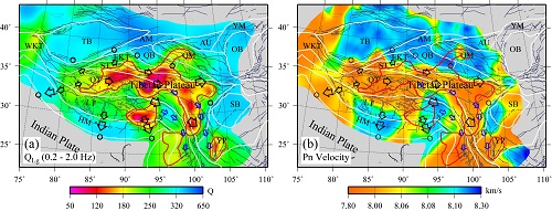
Vice Professor ZHAO Lianfeng and his team construct a 0.05–10.0 Hz broadband high-resolution crust attenuation model for the Tibetan Plateau and its surrounding regions using Lg-wave Q tomography. The maximum spatial resolution is approximately 1.0°×1.0° in well-covered areas and for frequencies between 0.05 and 1.5 Hz. This attenuation model reveals an apparent low-QLg belt stretching along the northern and eastern Tibetan plateau. Combining the Lg-wave Q model with other geophysical data, two possible crust flow channels are found in the Tibetan Plateau. The main flow channel is from north to east and then turns to southeastern Tibet along the western edge of the rigid Sichuan basin, while a second channel starts from southern Tibet and crosses the Eastern Himalayan syntaxis.
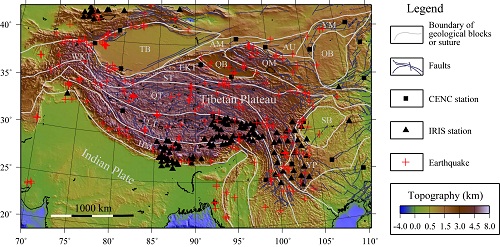
Fig. 1. A topographic map superimposed with main fault systems, regional tectonics in the Tibetan plateau and its surrounding regions. (Image by ZHAO)
Fig. 2. Comparison between (a) the average QLg (over 0.2–2.0 Hz) and (b) the Pn velocity in the Tibetan Plateau and surrounding regions. (Image by ZHAO)
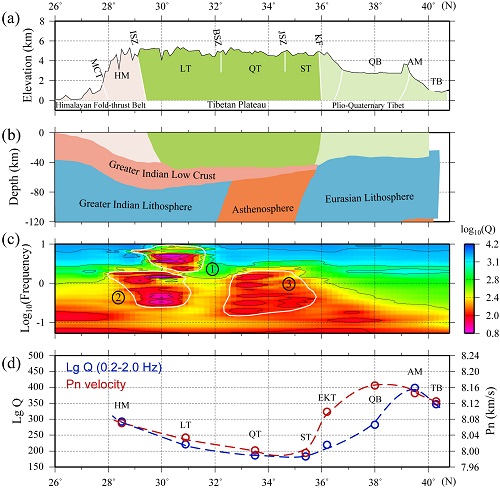
Fig. 3. A combined longitudinal cross section along 93° E, with (a) surface topography, (b) schematic crust and upper mantle structure, (c) log(QLg) versus frequency, and (d) comparison between average Lg Q and average Pn velocity for selected geology units. (Image by ZHAO) Zhao et al. Crustal flow pattern beneath the Tibetan Plateau constrained by regional Lg-wave Q tomography. Earth and Planetary Science Letters, 2013, 383: 113-122, doi: 10.1016/j.epsl.2013.09.038 (Download Here)
|
Contact
Related Articles
Reference
|
-
SIMSSecondary Ion Mass Spectrometer Laboratory
-
MC-ICPMSMultiple-collector ICPMS Laboratory
-
EM & TEMElectron Microprobe and Transmission Electron Microscope Laboratory
-
SISolid Isotope Laboratory
-
StIStable Isotope Laboratory
-
RMPARock-Mineral Preparation and Analysis
-
AAH40Ar/39Ar & (U-Th)/He Laboratory
-
EMLElectron Microscopy Laboratory
-
USCLUranium Series Chronology Laboratory
-
SASeismic Array Laboratory
-
SEELaboratory of Space Environment Exploration Laboratory
-
PGPaleomagnetism and Geochronology Laboratory
-
BioMNSFrance-China Bio-mineralization and Nano-structure Laboratory

 Print
Print Close
Close


