Surface deformation related to the 2008 Wenchuan earthquake, and mountain building of the Longmen Shan, eastern Tibetan PlateauUpdate time:03 08, 2011
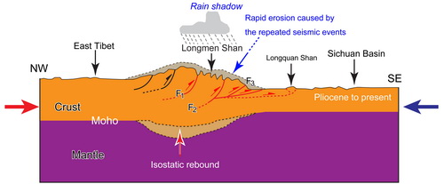
Professor FU Bihong and his team research on mountain building of the Longmen Shan, eastern Tibetan Plateau. Based on interpretations of post-earthquake high-resolution remote sensing images and field surveys, they have investigated the geometry, geomorphology, and kinematics of co-seismic surface ruptures, as well as seismic and geologic hazards along the Longmen Shan fold-and-thrust belt. These sub-parallel ruptures may merge at depth. The Yingxiu–Donghekou surface rupture zone can be divided into four segments separated by discontinuities that appear as step-overs or bends in map view. Surface deformation is characterized by oblique reverse faulting with a maximum vertical displacement of approximately 10 m in areas around Beichuan County. Earthquake-related disasters (e.g.,landslides) are linearly distributed along the surface rupture zones and associated river valleys. The Wenchuan earthquake provides new insights into the nature of mountain building within the Longmen Shan, eastern Tibetan Plateau. The total crustal shortening accommodated by this great earthquake was as much as 8.5 m, with a maximum vertical uplift of approximately 10 m. The present results suggest that ongoing mountain building of the Longmen Shan is driven mainly by crustal shortening and uplift related to repeated large seismic events such as the 2008 Wenchuan earthquake. Furthermore, rapid erosion within the Longmen Shan fold-and-thrust belt occurs along deep valleys and rupture zones following the occurrence of large-scale landslides triggered by earthquakes. Consequently, they suggest that crustal shortening related to repeated great seismic events, together with isostatic rebound induced by rapid erosion-related unloading, is a key component of the geodynamics that drive ongoing mountain building on the eastern Tibetan Plateau. The results have been published on Journal of Asian Earth Sciences. Fu et al. Surface deformation related to the 2008 Wenchuan earthquake, and mountain building of the Longmen Shan, eastern Tibetan Plateau. Journal of Asian Earth Science, 2011, 40: 805-824(Download Here)
Schematic tectonic evolution of the Longmen Shan and Sichuan Basin since the late Mesozoic. ( Image by FU Bihong)
|
Contact
Related Articles
Reference
|
-
SIMSSecondary Ion Mass Spectrometer Laboratory
-
MC-ICPMSMultiple-collector ICPMS Laboratory
-
EM & TEMElectron Microprobe and Transmission Electron Microscope Laboratory
-
SISolid Isotope Laboratory
-
StIStable Isotope Laboratory
-
RMPARock-Mineral Preparation and Analysis
-
AAH40Ar/39Ar & (U-Th)/He Laboratory
-
EMLElectron Microscopy Laboratory
-
USCLUranium Series Chronology Laboratory
-
SASeismic Array Laboratory
-
SEELaboratory of Space Environment Exploration Laboratory
-
PGPaleomagnetism and Geochronology Laboratory
-
BioMNSFrance-China Bio-mineralization and Nano-structure Laboratory

 Print
Print Close
Close
