|
Secondary Ion Mass Spectrometer Laboratory
|
Press
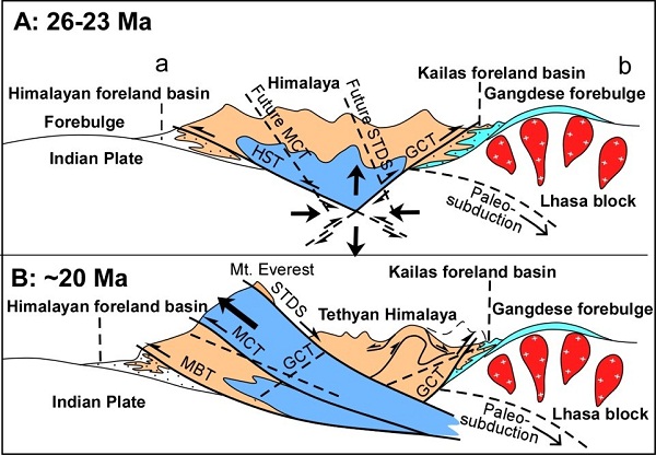
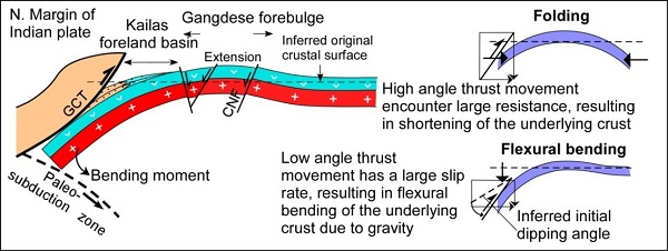
Scientific Reports: Flexural bending of southern Tibet in a retro foreland settingThe Indian and Eurasian plates converged continuously along the Yarlung Zangbo suture zone in Cenozoic. The early-stage convergence was present as northward subduction of oceanic lithosphere from the Indian plate, which led to the formation of a large-scale magmatic island arc belt on the southern margin of the Eurasian continent, known as the Gangdese belt. Late-stage convergence manifested as intensive collision of their continental lithosphere, forming the famous roof of the world – the Himalaya Mountains. Geoscientists have reached a basic common understanding about the subduction of the Indian plate oceanic lithosphere and the formation of the Gangdese magmatic island arc. However, great controversy still exists about the geological process that led to the formation of the Himalaya Mountains. Some researchers believed both Himalaya and Gangdese Mountains were formed by continuous northward obduction of the Indian plate. However, the southern margin of the Gangdese belt does not have any tectonic evidence of northward subduction of the Indian continent. For a number of years, Wang Erchie, a researcher at the Institute of Geology and Geophysics, Chinese Academy of Sciences, and his partners, have undertaken field geological mapping, structural analysis, sedimentary basin analysis, Ar/Ar, fissure track and zircon U-Pb and paleontology dating to investigate the formation of the Gangdese Mountains. Their recent work has shown that the Gangdese Mountains was not formed as a thrust belt, but that its uplift was controlled by the obduction of the Indian continent along the Great Counter Thrust, which is a northern boundary fault of the Himalayas. The gravitational load produced from the obduction of the Indian continent led to the flexural bending of the southern margin of the Gangdese Mountains, and can be characterized as a foreland system. The main part of the Gangdese Mountains was actually formed as a forebulge, coupled with a foredeep. This work revealed the uplifting of the Gangdese Mountains was unrelated to the southward thrusting, but the result of lithosphere flexural bending. Their research further revealed that the Yarlung Zangbo complex zone is a rootless thrust sheet with a northward displacement of approximately 70km. Moreover, this research proposed that the obduction of the Indian continent is controlled by compression and uplift of the Himalaya Mountains, which this suggests that the Himalaya Mountains experienced two tectonic stages: 1) An early-stage (~ 26-23Ma) orogenic process that was characterized by southward and northward thrusting of the Himalaya Mountains, which formed the Himalaya foreland basin to the south and the Kailas foreland basin to the north, respectively; and 2) a late-stage (22-20Ma) orogenic process that was dominated by large-scale southward thrusting. Many scholars have proposed numerous models for the tectonic evolution of the Himalaya Mountains. However, the expansion of geological surveying and data accumulation, modification of models is a necessity. The research by Wang Erchie and colleagues is based on large-scale geological observations and reliable data analysis, and these new understandings directly challenge one view held by geologists for a long time (i.e., development of the Himalaya tectonic belt was controlled by southward overthrusting from beginning to end). Thus, this research boosted the research on Himalaya tectonism. This work has been recently published in the open access journal Scientific Reports (Wang, E. et al. Flexural bending of southern Tibet in a retro foreland setting. Scientific Reports, 2015, 5: 12076; doi: 10.1038/srep12076).
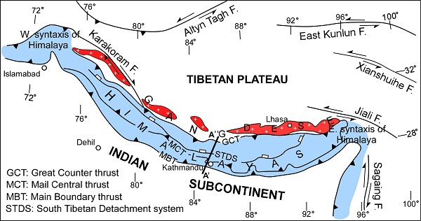
Figure 1. Generalized geologic and geomorphic map of the southern margin of the Tibetan plateau.
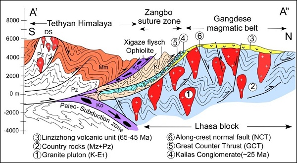
Figure 2. Generalized geological cross-section (A’-A”) between the Tethyan Himalayas and the Gangdese magmatic belt (southernmost Tibet) in the Xigaze area.
Figure 3. A proposed two-stage tectonic development of the Himalaya orogen.
Figure 4. Two-dimensional elastic-bending model of the southern margin of the Lhasa block. Contact
|
-
SIMSSecondary Ion Mass Spectrometer Laboratory
-
MC-ICPMSMultiple-collector ICPMS Laboratory
-
EM & TEMElectron Microprobe and Transmission Electron Microscope Laboratory
-
SISolid Isotope Laboratory
-
StIStable Isotope Laboratory
-
RMPARock-Mineral Preparation and Analysis
-
AAH40Ar/39Ar & (U-Th)/He Laboratory
-
EMLElectron Microscopy Laboratory
-
USCLUranium Series Chronology Laboratory
-
SASeismic Array Laboratory
-
SEELaboratory of Space Environment Exploration Laboratory
-
PGPaleomagnetism and Geochronology Laboratory
-
BioMNSFrance-China Bio-mineralization and Nano-structure Laboratory