The Bohai Sea and adjacent area is not only an important window for understanding the destruction process of the North China Craton (NCC), but also a key area for the comparative study of Chinese and Korean geology. Bohai is also one of the most important oil/gas production areas in China, so the study of the deep structures in this area is a key topic in the geoscience community. The number geophysical prospecting studies of the deep structures, however, is limited, only a few shallow seismic profiles and regional scale geophysical studies exist. Recently, with the rapid development of Ocean Bottom Seismometers (OBS), low-frequency large-volume airgun arrays, and wide-angle seismic data processing techniques, prospecting deep structures in sea area has become feasible.
In 2010 and 2011, researchers from the Institute of Geology and Geophysics, Chinese Academy of Sciences (IGGCAS) carried out onshore-offshore prospecting along two crossing survey lines in the Bohai Sea and adjacent areas by using a combination of homemade and imported OBSs (Fig 1). The research team used the First Arrival Tomography method to invert the shallow 2D velocity structure, and used the CMP stacking method to determine the depth of Moho. Based on this, they built the final 2D model using the Ray-tracing modeling method (Fig.2). Their results show that, moving further offshore, the upper crust thins, but that the middle and lower crustal thicknesses ca vary insignificantly. The velocities of the middle and lower crust shows gentle variation in the vertical direction, but distinct lateral velocity variations are observed due to the impact of fault zones. The velocity contours near the Tancheng-Lujiang (TLFZ) and Zhangjiakou-Penglai (ZPFZ) Fault Zones are U-shaped, where the velocity changes laterally and the interface undulates significantly. Velocity anomalies exist in the crust-mantle transition zone at the fault zone, which implies that the TLFZ and ZPFZ could be the upwelling channels of deep material. In the eastern part of the NCC, the Moho is generally at the depth of about 30 km, which suggests that lithosphere thinning occurred predominantly at the top of upper mantle.
These results were recently publishing in Journal of Asian Earth Sciences (Liu et al. (2015), Crustal Structure of Bohai Sea and adjacent area (North China) from two onshore-offshore wide-angle seismic survey lines, J. Asian Earth Sci. 98, 457-469). ( Link )
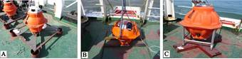
Fig.1 Three types of OBS used in the survey.
(a) OBS made by IGGCAS of China; (b) OBS made by GEOPRO of Germany; (c) OBS made by SERCEL of France.
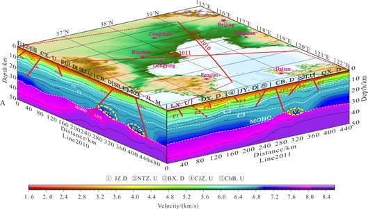
Fig.2 The deep velocity structures along the two onshore-offshore survey lines in Bohai region.